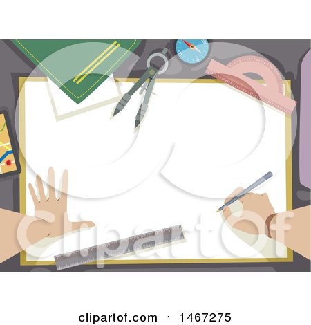
Poster, Art Print: Hands of a Cartographer with Drawing Tools by by BNP Design Studio's profile avatar BNP Design Studio

More cartography art prints & posters

Hands of a Cartographer with Drawing Tools Posters, Art Prints

Printable digital files available (ai eps jpg) #COLLCPR1467275


High resolution digital file options

Customer service   (estimated reply time: 5 minutes)

You may also like these

  1. Ornate Golden Compass
  2. Blue Map Of The Americas And Europe
  3. Green Map Of The World With A Honeycomb Pattern
  4. Blue Planet Earth Over A Map
  5. Blue Map Of The World With A Honeycomb Pattern
  6. Blue World Map Over A Lighter Blue Background With Bright Beams Of Light
  7. Blue Globe Showing The American Continents Over A Map Of North America In Blue Tones With Binary Code
  8. Map Of The Continents And Countries Of The Earth In Blue Tones
  9. Gradient Blue United States Of America Map With All Of The States On A White Background
  10. Four Blue Globes Showing Different Continents With A Flat Map Over White
  11. Unwrapped Gradient Blue Grid Map Of Planet Earth Showing The Continents Over A White Background
  12. 3d Rendered Globe Grids And Atlas Map In Blue
  13. 3d Rendered Blue Grid Globe In Front Of A Flat Atlas Map
  14. Compass And Grid Under A Blue World Map
  15. Shaded Relief Map Of The State Of California
  16. Shaded Relief Map Of The State Of Florida
  17. Shaded Relief Map Of The State Of Arizona
  18. Shaded Relief Map Of The State Of Alaska
  19. Shaded Relief Map Of The State Of Colorado
  20. Shaded Relief Map Of The United States
  21. 3d Globe Made Of Steel Over Black
  22. Gps Map 5
  23. Shaded Relief Map Of North America With The National Borders
  24. Shaded Relief Map Of North America With United States And Canada State And Provincial Borders
  25. Navigation Pin Over A Map With A Computer Mouse
  26. Cartoon Female Cartographer Creating A Map On A Computer
  27. Profiled Silhoutted Woman Using A Gps Map On A Mobile Phone
  28. World Map Background Globe Global Trade Concept
  29. Red Map Of The Americas And Europe
  30. Purple Map Of The Americas And Europe
  31. Green Map Of The Americas And Europe
  32. Blue Pixelated Map
  33. Gradient Red White And Blue Mape Of All Of The United States
  34. Map Of The Continents Of The Earth With Borders Of The Countries In Colorful Gradient Colors
  35. Map Of The Continents Of Planet Earth With Borders Of The Countries In Green Tones
  36. Colorful Map Of The Continents And Countries Of The Earth In Blue Green Red Orange And Purple
  37. Gradient Red Orange White And Blue United States Of America Map With All States On A White Background
  38. Map Of The Continents And Borders Of The Countries Of The Earth In Colorful Tones
  39. Nine Green Global Views Of The Different Continents Of Planet Earth
  40. Nine Global Views Of The Different Continents On Planet Earth In Blue Tones
  41. Nine Views Of The Continents On Planet Earth In Orange And Tones
  42. Unwrapped Blue Grid Map Of Planet Earth Showing The Continents Over A Blue Background
  43. Unwrapped Green Grid Map Of Planet Earth Showing The Continents Over A Green Background With Grids On The Top And Bottom
  44. 3d Rendered Globe Grids And Atlas Map In Red And Orange
  45. 3d Rendered Navy Blue Grid Globe In Front Of A Flat Atlas Map
  46. Compass In The Lower Corner Of A Blue Atlas
  47. Wave Of Financial And Payment Term Text Over Lines On A Blue Atlas
  48. Shiny Blue Education Subject Icons
  49. Planet Earth Being Separated Onto Different Pieces
  50. Shaded Relief Map Of The State Of Georgia
  51. Shaded Relief Map Of The State Of Alabama
  52. Shaded Relief Map Of The State Of Delaware
  53. Shaded Relief Map Of The State Of Connecticut
  54. Shaded Relief Map Of The State Of Arkansas
  55. 3d Globe With Floating Orange Continents And Black Oceans
  56. Shaded Relief Map Of The State Of Nevada
  57. Shaded Relief Map Of North America As Seen From Space
  58. Shaded Relief Map Of The Hawaiian Islands
  59. Shaded Relief Map Of Chad
  60. Shaded Relief Map Of Angola
  61. Shaded Relief Map Of Burma Myanmar
  62. Shaded Relief Map Of Bangladesh
  63. Shaded Relief Map Of Cambodia
  64. Shaded Relief Map Of Haiti
  65. Shaded Relief Map Of Cameroon


Verify Captcha to Proceed

Captcha

Please submit one alphabet letter to prove you are not a robot crawler.